S.O.S

enviro1.jpg

 
Here I mention that all I have learned is because of my training in the department of sociology in National University of Iran especially under order of Prof. Dr. Faramarz Rafipoor who was my coach in doing my thesis.
 
Special thanks to him and all of my trainers,
 
 -----------------------------------------------
Presented in Department of Sociology,

National University of Iran - 2000

(A Thesis for a M.A degree )

Shahrouz Falahatpishe 

E-mail: shahrouz98@hotmail.com

 URL: http://falahatpishe.tripod.com

07.jpg

matn.jpg

The Role of Government in Natural Environmental Degradation in Urban Areas :

 Four decades urbanization in Shemiran

As a result of the limitations of this research (i.e., time and budget) we limited the meaning of natural environment to the green spaces and farmlands in urban areas in the northern part of Tehran; a palace named Shemiran that used to be, and some degree still is, the greenest area in this the capital city of Iran.

As the essence of problem, it was an interdisciplinary thesis that had a share of sociology, geology and urbanity but the most emphasis was on the role of environmental sociology in explaining the problem.

In literature review you can find meanings like:

1- Ecological variables

2- POET and IPAT models

3- Political economy

4- Treadmill of production

5- Urbanism

6- Urban policy

7- Land tenure

8- Urban sprawl

9- Environmental Policy obligations

10- New environmental paradigm (NEP & HEP)

11- Environmental ethic

12- Land ethic

13- Gaia hypotheses


In this thesis the research method involved completing three separate steps :

1- Documenting the magnitude of environmental degradation.

2-Identifying the role of governmental rules in negatively impacting the natural environment in urban areas.

3- Assessing public opinion concerning the problem


In following sentences I describe each step in more details:

STEP 1:

As there was no data about the problem (No governmental bodies cooperated with us because of political dimension of present problem and also they did not have such data), we decided to build it for ourselves.

First of all we prepared all the existing aerial photos (1956,1969,1979 & 1991) and accordingly we prepared four green maps for the region, one for each set of photos available.

To measure the scope of degradation we used AutoCAD software and using the drawn green maps as the base we made a digitized map for each of the four years. The commands in the software helped us to calculate the scope of changes in the green spaces and farmlands into constructed areas (the lose of land cover as a result of land use) and so our measure of degradation.

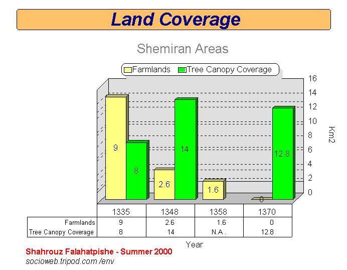
The indicator used in measurement is named "Tree Canopy Coverage or T.C.C." that means the size of coverage of green spaces [and farmlands] as viewed from the sky (by airplane or satellite).

According to the calculated figures between 1956 to 1969 we have had an increase in TCC. From 1969 to 1979 and until 1991 there have been decreases in green spaces and farmlands in the urban areas (some farmlands used to be in heart of the region).

STEP 2:

As we were going to find the role of government in this kind of degradation, we reviewed all of the planning and urban rules in governmental documents and showed where and how some rules make this degradation possible.

We made a link between digitized maps and the related governmental rules .We also used some of the historical and statistical documents about growing Tehran and Shemiran.

STEP 3:

We interviewed people who were born or living in the mentioned area before 1940 decade [This means that all of the people we interviewed were really old ] . For this purpose we used a questionnaire with questions designed according to the variables explained in the literature review and also resulting from the findings from steps 1 and 2.

The result of this section were compared with our findings in steps 1 and 2 and also the network of variables in the literature review.

At the end of this research, using a combined 3 steps method and using the perspectives of sociology, geology and urban studies, we believe that we have demonstrated how the governmental rules and decisions directly or indirectly made it possible to destroy the green spaces and farmlands in the area of Shemiran in north of Tehran .

deg1.jpg


To have a more clear understanding of thesis, I give the full table of contents:

  •          Preface

  1. Introduction

    1-1. Subject importance

    1-2. Objects

  2. Theoretical framework

    2-1. Problem definition

    2-2. The role of sociology in consideration of environmental problems

    2-2-1. Environmental sociology

    2-2-1-1. Affective factors in environmental degradation

    2-2-1-1-1. Ecological explanation

    2-2-1-1-1-1. POET model

    2-2-1-1-1-2. IPAT model

    2-2-1-1-2. Political economy explanation

    2-3. Urbanization and environmental degradation

    2-3-1. Urban policy

    2-3-2. Real state market and urban economy

    2-3-2-1. Land directed development

    2-3-3. The most regular form in expanding urban areas

    2-4. The role of government in environmental protection

    2-4-1. Political obligations in environmental protection

    2-4-1-1. Need to knowledge

    2-4-1-2. Need to an ethical approach

    2-4-1-2-1. New environmental paradigm

    2-4-1-2-2. Land ethic

    2-5. Discussion brief

    2-5-1. Causal network in present research

  3. Research method

    3-1. Proving degradation

    3-1-1. Limiting the area

    3-1-2. Regulations to determine the area

    3-1-2-1. Use the map of area

    3-1-2-2. Use the regional aerial photos

    3-1-3. Measurement of environmental degradation

    3-1-3-1. Land history

    3-1-3-1-1. Related organizations data

    3-1-3-1-2. Satellite pictures

    3-1-3-1-3. Aerial photos

    3-1-3-2. Regulations to determine the time periods

    3-1-3-3. Instrument to measure degradation

    3-1-3-3-1. Use of AutoCAD software

    3-1-3-3-2. Preparing green maps

    3-1-3-3-3. Preparing digitized maps

    3-1-3-3-4. Calculating the scope of degradation

    3-1-3-3-5. Transforming the calculated figures to real figures

    3-2. Evaluating the governmental rules

    3-2-1. Review the urbanity rules

    3-2-1-1. Documents studies

    3-2-1-2. Consolation with urbanity specialists

    3-3. Public opinion about the problem

    3-3-1. Degradation measurement and affective factors

    3-3-1-1. Degradation measurement

    3-3-1-2. The role of ecological limitation in degradation possibility

    3-3-1-3. The role of urbanity rules in degradation possibility

    3-3-1-4. Considerable variables in present research

    3-3-1-4-1. Personal variables

    3-3-1-4-2. Land use history

    3-3-1-4-3. Dependent variable (degradation)

    3-3-1-4-4. Ecological limitations

    3-3-1-4-5. The role of government and governmental rules

    3-3-2. Sample society

    3-3-2-1. Regulations for choosing a responder

    3-3-2-2. Regulations for choosing an area

    3-3-3. Method of sampling

    3-3-3-1. Quantity of sample

    3-3-4. Adjusting the questionnaire

    3-3-5. Choosing and training the interviewers

    3-3-6. Pretest interview

    3-3-7. Final interview

    3-3-8. Data bringing out

  4. Findings

4-1. Environmental degradation in Shemiran area

4-1-1. Historical process of degradation

4-1-1-1. Shemiran area in Qadjars regime period

4-1-1-2. Shemiran area in Pahlavis regime period

4-1-1-2-1. Results of measurement the scope of degradation

4-1-1-3. Shemiran area after 1978 ; Islamic revolution

4-1-1-3-1. Results of measurement the scope of degradation

4-1-1-4. Final result of degradation measurement

4-2. The role of governmental rules in degradation

4-2-1. Tehran general project (approved in 1968)

4-2-2. Tehran general project (approved in 1991)

4-2-3. Evaluating the urbanity rules

4-2-3-1. The rule of conservation and expansion green spaces

4-2-3-1-1. The rule of conservation, expansion and prevention of tree irregular cutting

4-2-3-1-2. The bill of conservation and expansion green spaces in cities

4-2-3-1-3. Comparative study of rules related to conserve green spaces

4-2-3-2. Urban renovation and civil rule

4-2-3-3. Urban land rule

4-2-3-3-1.The role of canceling ownership right on unprofitable lands in changing land cover

4-2-3-3-2. Urban land rule in 1981

4-2-3-3-3.Urban land rule in 1987

               4-2-3-3-4. Urban land rule after 1993

4-2-3-4. Rules related to construction and accumulation in buildings

4-2-3-4-1. Evaluating the structure of rules

4-2-3-4-1-1. Rule deficiency

4-2-3-4-1-2. Rule violation

4-2-3-4-1-2-1. Article seven commission

4-2-3-4-1-2-2. Article five commission

4-2-3-4-1-2-3. Agreements commission

4-2-3-4-2. The role of social situation in output of rules

4-2-4. Discussion result

4-3. public opinion about degradation process

4-3-1. Frequency of personal variables

4-3-2. Frequency of land use history in region

4-3-3. Frequency of dependent variable

4-3-4. Frequency of independent variables

4-3-4-1. Frequency of ecological limitations

4-3-4-2. Frequency of role of government and rules in degradation possibility

4-4. Discussion result

5-Summary

NEWSLETTER OF RESEARCH COMMITTEE 24

A historical text about old Shemiran with English translation;

A Day in Rostamabad of Shemiran

by Mohammad-Ali Jamalzade's